Bageshwar is one of the 13 districts of northern Indian state of Uttarakhand. It is also one of the six district that make Kumaon division along with Nainital, Pithoragarh, Champawat, Almora and Udham Singh Nagar. The town of Bageshwar lies at the confluence of Saryu and Gomati rivers. Bageshwar map consists of its all 4 tehsils, namely:
- Kapkot
- Bageshwar
- Garud
- Kanda
Contents
show
Bageshwar Map with its Borders:
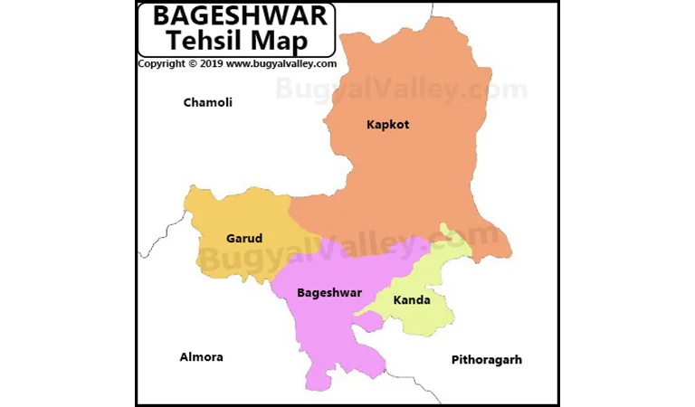
The above map of Bageshwar contains its 4 tehsils and neighboring districts. The borders of Bageshwar district touch:
- Chamoli district in the west and north-wast
- Almora district is the south and south-west
- Pithoragarh district in the east and north-east
Few Facts about Bageshwar District:
- As per the census data of 2011, Bageshwar district had a total population of 259,898 of which male and female were 124,326 and 135,572.
- Bageshwar district is 3rd least populous district of Uttarakhand after Champawat and Rudraprayag.
- This entire region was once known as Danpur and ruled by Katyuri kings during the 7th century.
- It was once a tehsil of Almora district and became an independent district in 1997.
- The Gorkha kings ruled the area for 24 years. After that East India Company defeated them in 1814 and it came under the Britishers.
- Bageshwar is a popular hill station. It is known for its beautiful landscapes, glaciers and rivers.
- Apart from tourism, Bageshwar district is home to some of the most important and ancient Hindu temples. For example, Bagnath temple and Baijnath temple. Bageshwar gets its name from the historical Bagnath temple.
- Being a Kumaoni district, Kumaoni language is widely popular in the region. However, most of the population speaks Hindi. Sanskrit and Hindi are the two official languages of Bageshwar district.
- Bageshwar was a part of Almora district after independence. It had a total population of only 1740 people as per the data of the 1951 Census of India.